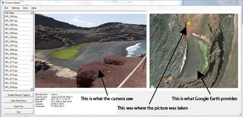
Let me ask you a question, have you ever looked at one of your own pictures and thought "that's a good picture. I wonder where it was taken ?". Well now that's not a problem anymore. With GTrek's GeoTagging features you will never have to ask that question again. Until now, to view that data you would have needed to use the GTrek program or an external web site such as flickr.com and GeoTagged the image manually.
With GTrek's-GeoTagger you can view all the major image file formats (see below), display image information and GeoTagged data in textural form as geographical coordinates and as an actual location in Google Earth.
OK, your pictures are not GeoTagged !! (you don't have a GTrek, shame on you). Well GTrek-GeoTagger has the ability to manually do that for you as well (Pro version needed). Or use a free smartphone app to gather the GPS data for you.

|


